Remains of the Via Sebaste, the Roman road where the journey narrated in my novels begins.
If you were asked to name ten factors that enable a nation or civilization to succeed, you might not think to include “good roads” on your list. We are so used to having an effective network of roads that we take them for granted, and we complain when potholes, road work, or traffic keep us from traveling at top speeds.
In the ancient Mediterranean world, by contrast, the availability and quality of roads varied considerably. Paved roads are known as early as the third millennium BCE in Egypt, but most roads outside the cities were little more than irregular beaten earth tracks until the Assyrians, the Persians, and above all the Romans began constructing a coherent system of roadways to move armies and trade across their empires in the first millennium BCE.
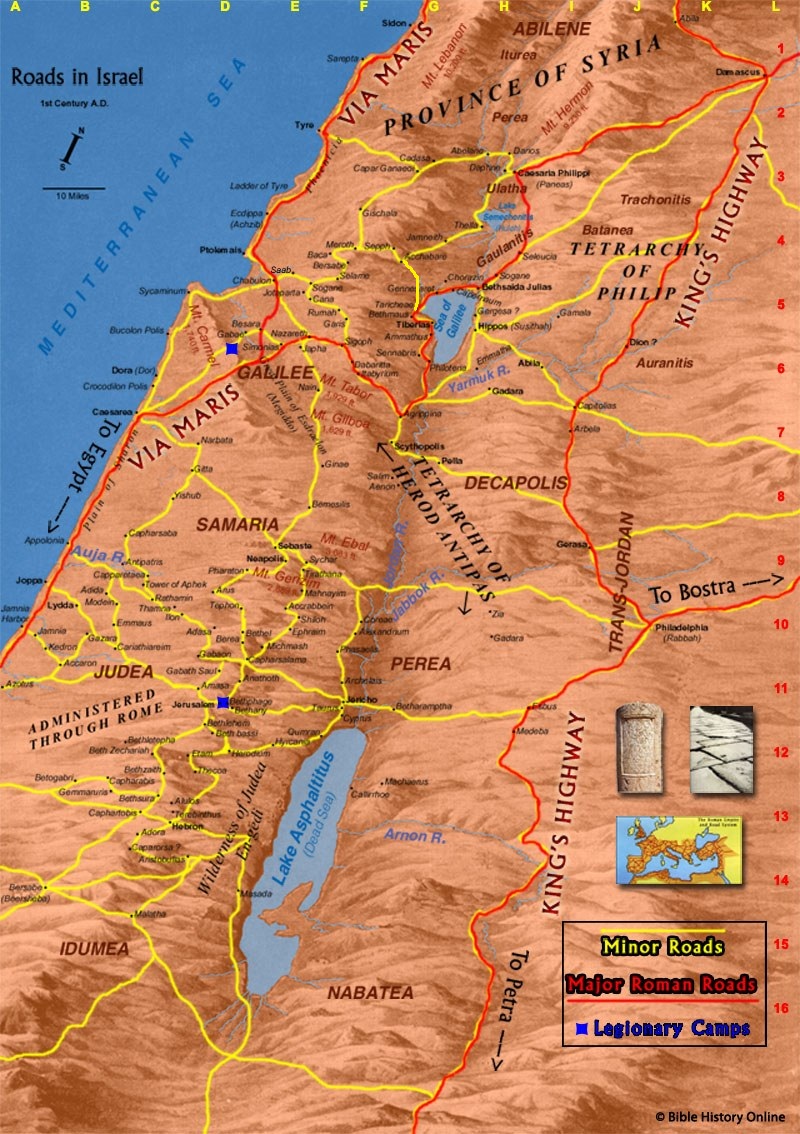
Asia Minor (modern Turkey), where my novels take place, benefited particularly from these road-building efforts due to its strategic position as a land bridge between Asia and Europe. The route that my characters take from Antioch to Ephesus (shown on the map below) includes sections of three major Roman roads that linked the cities of southwestern Asia Minor: the Via Sebaste (which would have been fairly new at the time of my story), the Cilician Road (possibly built in the first century BCE), and the Road of Manius Aquillius (second century BCE). The roads that they use to get from Ephesus to Pergamon and from there to Hierapolis would have been built before the coming of the Romans, but the Romans upgraded them.

Map of southwestern Asia Minor (Turkey) showing the route of the journey narrated in my novels; other roads are marked with red lines.
Roman roads were paved with large, flattened stones laid over deep beds of crushed rubble that made them both stable and durable. The quality of their construction can be seen in the numerous examples of Roman roads that remain strewn across the Turkish countryside.


A particularly well-preserved stretch of Roman road in western Asia Minor, not far from where the characters in my “A Slave’s Story” trilogy would have traveled
Easy-to-carry road maps did not exist in the ancient world, but travelers could purchase an itinerarium that listed the cities, villages, and other points of interest along a route and the number of miles between them. On the road itself, every mile was marked by a stone column (thus the term “milestones”). Some of these columns were inscribed with information about who built the road and how far one was from the end of the road, like the one below that was found five miles east of Ephesus. Interestingly, the inscription gives more prominence to the name of the Roman governor who commissioned the road (Manius Aquillius) than to the distance (the “E” at the bottom signifies five miles).